Hiking and Photography, Slieve Carr, Ballycroy National Park. 📷
“The mountains are calling and I must go.”
John Muir
I found myself in the middle of the COVID-19 pandemic last August and decided to do something a little bit different. With travel restricted to within my county borders, I thought it would be a nice idea to head into the wilderness of Ballycroy National Park and climb Slieve Carr, renowned for being the remotest place in the country.
Ballycroy National Park is located in north County Mayo in the Nephin Beg/Owenduff area of the Barony of Erris. It is one of the largest expanses of blanket bog in Europe, consisting of 120 square kilometers. It is a unique habitat with a diverse flora and fauna.
While doing some research for the trip, I came across an excerpt from the aptly named book written by the botanist Robert Llyod Praeger, “The Way that I Went," extolling the virtues of this area, and I wondered whether it might be possible to experience some of the same "spirit" Praeger felt when he visited this area and recorded his journey nearly 100 years ago.
" Indeed Nephin beg range of mountains is I think the very loneliest place in this country, for the hills themselves are encircled by this vast area of trackless bog … I confess I find such a place not lonely or depressing but inspiriting. You are thrown at the same time back upon yourself and forward against the mystery and majesty of nature.”
Robert Lloyd Praeger – The Way That I Went (1937).
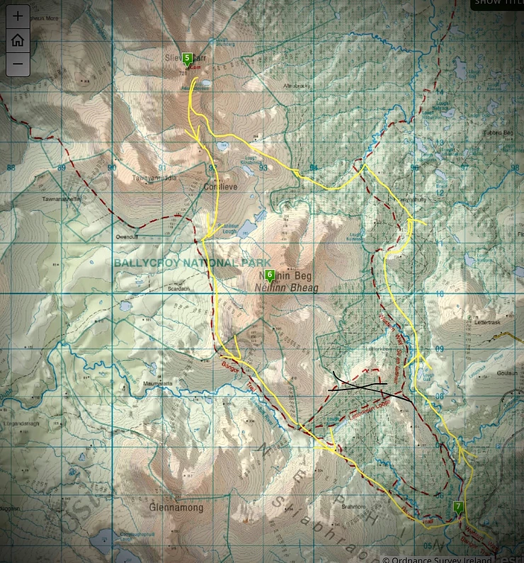
OS map 23, route in and out from the Letterkeen trailhead (Start line number 7, summit number 5).
The Trip
My planned route is to park at the car park at the Letterkeen trail head in Srahmore, Newport, and follow the Western Way Trail to a particular spot where I can breakout out of the Altnabrocky forest to ascend Slieve Carr from the east. Climb on to Carr’s 400-meter-long plateau at about 500 m by following a dry river gully upwards. Set up camp somewhere suitable near the cairn and get something to eat. My plan is to spend the night here and then break camp in the morning and head down over Corslieve towards the Scardaun Lakes, turning west to connect with the Bangor Trail, which leads back to Letterkeen.
Most of the Western Way Trail I walked on is made up of the Coillte-owned Alnabrocky pine forest, which stretches out for many kilometers in every direction. It is only when I climb onto the elevated slopes of Slieve Carr that I see and appreciate the full extent of the forest, with its numerous lakes and pools scattered in between the trees.
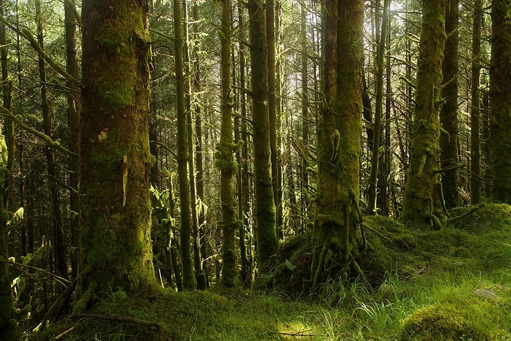
Alnabrocky forest.
The trail is good and dry for trekking on as I follow the loggers' route in towards the mountain. After hiking about 10 kilometers and with a gradual overall rise of about 200 meters, I come to the first of the rural shelters called Altnabrocky Wilderness Hut 2.

Altnabrocky Hut number 2.
There are a few of these huts dispersed throughout the park that offer the traveler a place to rest and shelter if needed. They are of simple timber construction, with a bench and seats for comfort. Also interesting to note is that each of these huts holds a logbook where you can record your own hiking and camping visits in the area and leave comments as to your experience. It is always a good idea to record your visit because all comments are considered with a view to improving future trips for visitors.
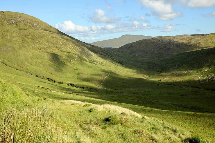
As I continue my journey past this hut towards Slieve Carr, I come across a timber stile in the trees. Climbing out over it brings me out of the forest and into the open landscape. From here, I must contour around the left side of a hillock and gradually ascend as I follow the contours in towards Slieve Carr. It is also here that I get my first good look at the mountain and see that, in reality, my climb is just getting started.
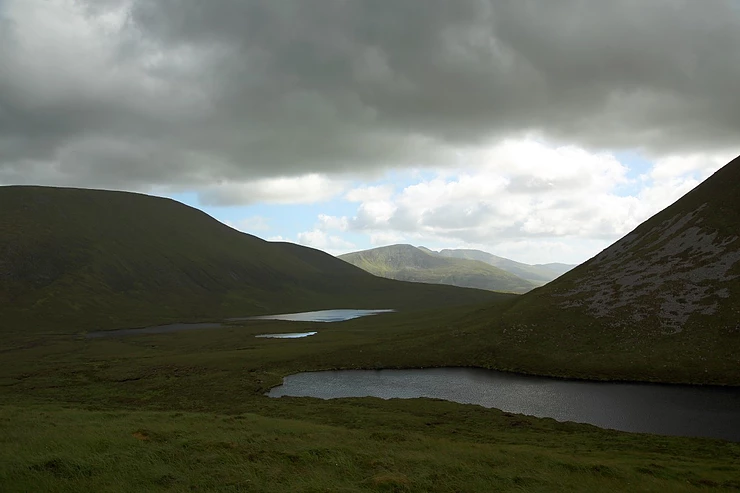
First glimpse of Scardaun lakes and lough Kilnabinnia. Glenamong in the background from the spur looking west.
Continuing on along the spur and keeping Lough Kilnabinnia and an unnamed lake (number 389 on the OS map) to my left, I follow the fairly steep river gully up until I reach the plateau on top of Slieve Carr. I still have about 200 meters to climb before reaching the summit. It is still a bit of a climb to get to the top as the ground here is wet and boggy with a lot of rocky scree in places, especially near the top.
Slieve Carr, 721 Meters and Laghtdauhybaun

The Cairn on the rocky summit of Slieve Carr looking north.
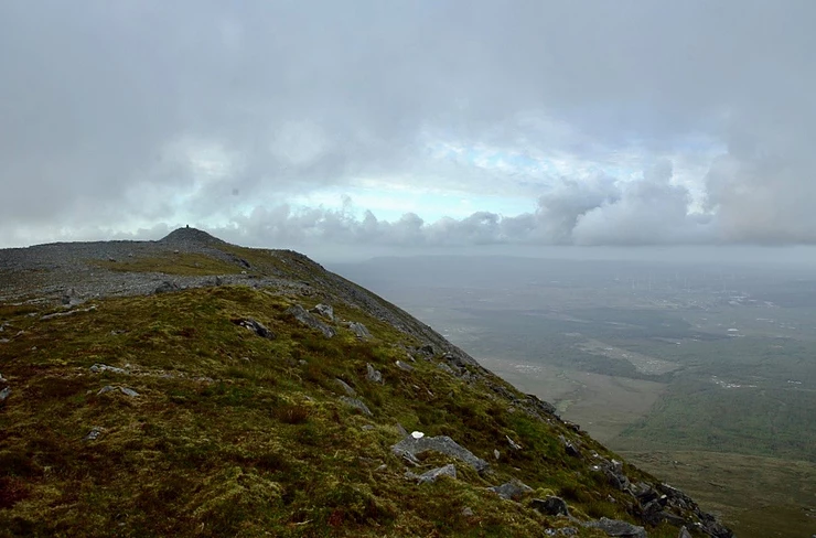
Summit of Slieve Carr looking North.
“Geoffrey Keating in his Foras Feasa ar Éirinn (History of Ireland, ca. 1634) and also by Duald Mac Firbis in the Genealogies, Tribes and Cusoms of Hy-Fiachrach (1650) tells of the voyage to the continent of King Dathi of Connacht, the last pagan king of Ireland, in order to avenge the death of Niall of the Nine Hostages. He dies in AD 427 when struck by lightning on Sliabh Ealpa (taken to be the Alps). His army, led by his son Amalgaid, fights a number of battles to bring his body back to Ireland to be buried in the Releg of Cruachan. (Rathcroghan Co Roscommon). The places in Europe mentioned in this account were identified by Sir Samuel Ferguson, but Hubert Knox, (Ballinrobe Knoxes) author of the History of the County of Mayo, rightly doubts its historicity.
Instead he suggests that Sliabh Ealpa where Dathi died was not the Alps, but rather Slieve Alp near Ballycroy, and that the tale of the invasion of the Roman Empire was an inspired piece of fantasy concocted by somebody unaware of [or deliberately ignoring] the existence of Slieve Alp in Mayo. The association of Dathi with this part of Mayo may be confirmed by the presence of a cairn named Laghtdauhybaun on Slieve Carr and Lough Dahybaun near Bellacorick [Knox, 25-26].”
Paul Tempan Irish Mountain Placenames.

Slieve Alp in the foreground, looking west towards Ballycroy and hill 243 with Slievemore and Croaghaun in the right background.

Misty sunset from the summit looking through the clouds.
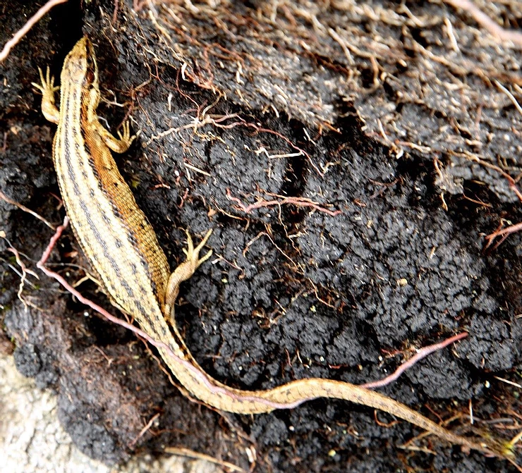
When I finally reach the top and have a chance to look around, it is nice to see that some of the local wildlife makes an appearance in the shape of lizards and frogs. I think that it must be the presence of the many water pools and peaty soil that helps them survive and flourish here at this high elevation.
Viviparous or common lizard.

Common frog.
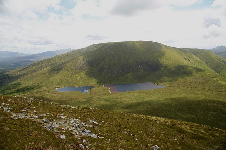
Early the next morning, I pack up camp and start to head down on my return journey. On the way down, I stop on the plateau at Corslieve, and I am suddenly taken aback by the sheer beauty of the vista that has appeared in front of me.

Standing on Corslieve looking west. This vista from Nephin Beg on the left to Glenamong and the Corranabinnias in the middle and to Slievemore and Croughan on Achill Island on the right is a sight to behold. Looking over the Owenduff and Baunduff river valleys afford an awesome sight.
From my vantage point on Corslieve, I look down and see the two Scardaun lakes and the river, which are heading west in the same direction that I will be following. I slowly descend down the steep incline, threading very carefully so as not to overbalance and fall on the slippy surface, and slowly I finally make it down about 300 meters to the Scardaun River.
Standing on the top of Corslieve looking south down on the Scardaun lakes with Nephin Beg behind
From the Scardaun lakes, I follow the river west. Further down and around the end of a spur, I come on a beautiful waterfall, from where I catch my first good glimpse of the famous wandering Bangor Trail meandering majestically away in the distance through the Bawnduff River valley.

Waterfall on the Scardaun river with Glenamong in the background.
As I continue down the river, I reach the Bangor trail, and I have a feeling that due to the amount of rain that has fallen in the previous weeks, the trek will be fairly wet and slow moving further out on the trail.
Bangor Trail
The Bangor Trail follows an old drover path which may date from the Iron Age. There is along the route, evidence of previous human habitation, particularly from the mid-19th century just prior to the Irish Famine when population pressure in this area was intense. In the days (16th century until early 20th century) when English landlords owned vast estates across Ireland, fishing and hunting lodges abounded, especially beside the rivers and lakes, which were used seasonally for red deer and shooting expeditions and the leisure activities of the aristocracy. The landlords would have been responsible for the maintenance of sections of the trail which passed through their lands. The trail was the main route for people and livestock before roads were built in the area in the first half of the 19th century.

A final look back at Slieve Carr looking in the direction of the Bangor Erris.
The trail meanders onward and upward over the hills.

A house dwelling ruin sitting on the side of the the Bangor Trail.
Mountain Meitheal Shelter

Shelter built by Mountain Meitheal.
Coming out of the wet trail, the path returns to a stoney type track, and I begin to notice some maintenance work done on the pathways in the form of new stepping stones and boardwalks, etc. I look up and notice another shelter just off the trail, and I head up to it to take a look and note that it’s a mountain Meitheal hut. After experiencing a trek as good as this, it would be remiss of me not to mention this wonderful organization, whose members work at improving the mountain trails and shelters on a volunteer basis for us all to enjoy.
Mountain Meitheal, founded in 2002 offers the opportunity to give something back by volunteering to work on trails thereby protecting our fragile environment. They work in partnership with other bodies such as the Coillte, the Dublin Mountain Partnership, National Parks and Wildlife Service, the Wicklow Way Partnership and also with private landowners. Mountain Meitheal supports and endorses the work of Leave No Trace Ireland. Volunteers and third parties are insured through the Mountaineering Ireland insurance scheme.
To date the group has built 14km of trails in upland areas, built and repaired bridges; They have constructed three emergency shelters on the Wicklow Way, one on the Bangor Trail and one on the Western Way in County Mayo. They run training courses periodically. They are self financing and depend on contributions from their supporters to fund their projects.
Mountain Meitheal Ireland was formed in 2015 as the governing body for all Mountain Meitheal branches and aspirant branches. There are currently two branches, Mountain Meitheal Dublin Wicklow and Mountain Meitheal South East.
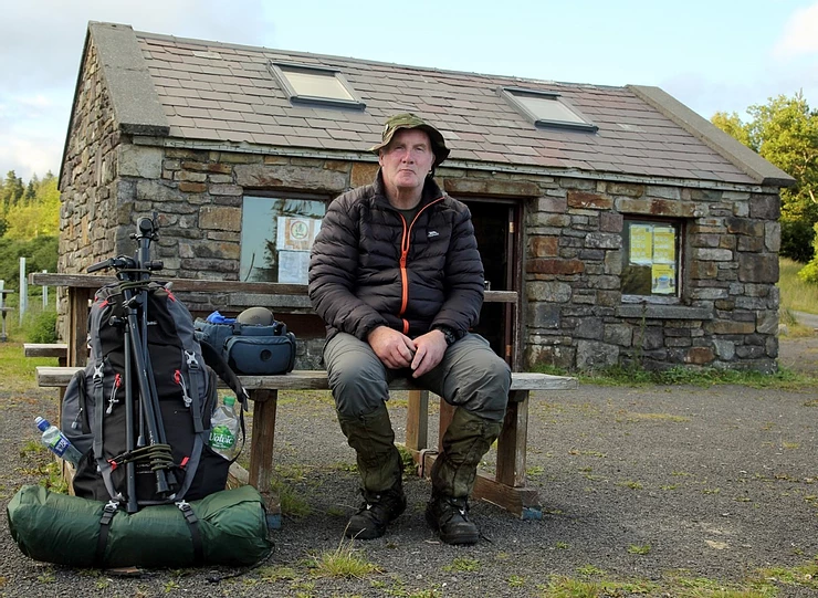
End of the adventure, at the Brogan Carroll Bothy Letterkeen.
After a few more kilometers, I returned to the Brogan Carroll bothy in Letterkeen at 2000 hrs on Sunday after leaving here at 1200 hrs the day before. A round trip of about 30 kilometers results in a memorable trek that will not be soon forgotten. Along with many lessons learned and memories to cherish, it's amazing to think that I've just returned from Ireland's most remote location.
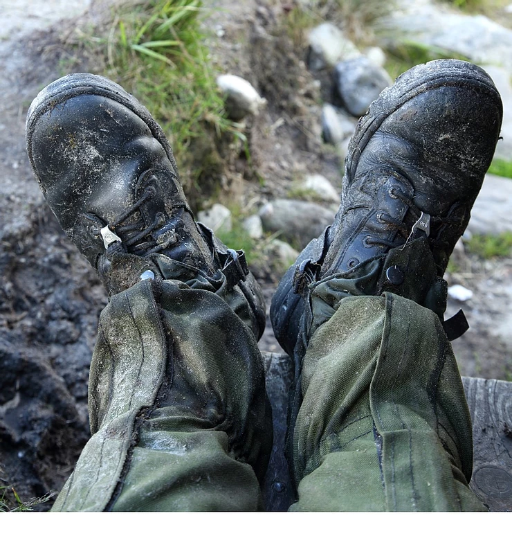
Time for a rest, Feet up, you just can’t beat a good pair of well worn Army Magnum boots and pair of Army Gaiters to boot !